Preview
Description
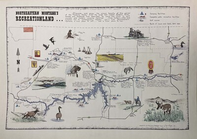
Map print of Northeastern Montana's Recreation Land.
"Discover and enjoy the unique beauty of this corner of the Treasure State, from the rough and rugged Missouri River breaks and badlands first described by Lewis and Clark to golf courses and modern camping facilities... from historic sites and frontier fun to contemporary theater, you'll find Northeaster Montana a nice place to visit... and a nicer place to live."
The map depicts colored drawings at each of the sites mentioned on the map.
Prepared for the Valley County Development Council by Rita A. Pauloski
Keywords
Map, Print, Drawing, Artwork
Original Medium
Colored Pencil, Ink, and Paper
Item Size
42.9 cm x 60.7 cm
Origin
Valley County, Montana, United States
Date Information
1970
Artifact Number
M76-119
Original Collection
Mike Mansfield Collections, Mss 65, Archives and Special Collections, Mansfield Library, University of Montana
Holding Repository
University of Montana, Mansfield Library Archives and Special Collections
Digital Publisher
University of Montana-- Missoula. Mansfield Library
Image Credit
Image credit: Micaela Connolly, University of Montana
Contact Us
For additional information about the collection or to suggest a keyword or share what you know about this item email library.archives@umontana.edu. Please include the artifact number in your note to us.
Rights
Keywords
Map, Print, Drawing, Artwork