B. Bathymetry and Survey Lines
Files
Description
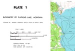
Image of blue line copy of original survey track line and bathymetry map. Image editor enhanced version of the image of the copy of the original map.
Date
8-1971
Subjects
Flathead Lake bathymetry, Flathead Lake seismic survey line locations
Disciplines
Earth Sciences | Geophysics and Seismology
Recommended Citation
Silverman, Arnold J.; Pevear, David R.; and Prahl, Sidney R., "B. Bathymetry and Survey Lines" (1971). 1970 Flathead Lake Seismic Survey. 15.
https://scholarworks.umt.edu/flathead/15